Land Subsidence in Arizona
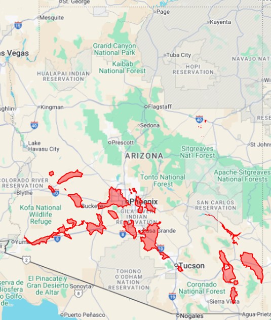
Land subsidence has been occurring across Arizona since the early 1900s. Millions of people around the world live in active land subsidence areas, many of whom may not even realize it. Most of the time, there is no clear and identifiable sign that land subsidence has occurred in an area. Areas in Maricopa and Pinal Counties have subsided more than eighteen feet since the early 20th Century.
Land subsidence in the basins of Arizona is generally due to compaction of alluvium caused by lowering of the water table. As the water table declines, pores in the alluvium once held open by water pressure are no longer supported and collapse. Collapse and subsequent lowering in elevation of the land surface is defined as land subsidence. This subsidence is generally not recoverable. If this subsidence occurs over areas of bedrock, differential subsidence can occur.
Differential subsidence is when adjacent areas subside at different rates. Bedrock will not compress like the surrounding alluvium, creating a subsurface platform. Differential subsidence occurs where shallow bedrock and deep bedrock are adjacent to each other, creating a zone of differential change in surface elevation. Because of these different amounts of subsidence, tension can build in the alluvium layer at this differential subsidence zone, forming an earth fissure.
Arizona Land Subsidence Areas
Earth Fissures
Earth fissures are cracks at or near the earth’s surface that are the result of differential subsidence. Earth fissures start out as small cracks and may not be visible on the surface. They grow and widen from surface water flowing into the crack, eroding material from the sides.
Earth fissures have caused millions of dollars in property and infrastructure damage, damaging pipelines, roads, canals, flood retention structures, bridges, buildings, and private property. There are unanswered questions about how earth fissures interact with groundwater pollution.
Impacts Of Land Subsidence & Earth Fissures
There are many consequences of land subsidence and earth fissures. The associated elevation and slope change can affect the natural floodplain drainage and the flow within canals and drains. It can also damage intermodal infrastructure (roads, bridges, railways, etc.), water-retention and retarding structures (dams, levees, floodways, etc.) and private properties (homes, driveways, fences, etc.).
Earth fissures are identified by using the ground and aerial monitoring techniques. The Arizona Geological Survey (ASGS) started an intensive earth fissure mapping program in 2006. The goal of this program is to survey and record each known earth fissure around the State and provide this data to the public.
Land Subsidence Monitoring
Land subsidence has been detected over the years using surveying techniques such as differential leveling and high accuracy Global Positioning System (GPS) surveying. In the early 1990s, scientists began to use Synthetic Aperture Radar (SAR) and interferometric processing (InSAR) to detect land surface elevation changes. InSAR has been developed into a highly reliable land subsidence monitoring technique that has been utilized by the Arizona Department of Water Resources since 2002. ADWR has identified numerous subsidence features around the State and continues to monitor the extent and rates of these features on an annual basis.
Land subsidence maps were developed by ADWR using archived and current InSAR data with the goal of providing hydrologists, geologists, water managers, and the public the most accurate land subsidence data.
ADWR is also part of the Arizona Land Subsidence Group which was jointly created by the geological and engineering communities as a venue for discussing the state of knowledge regarding subsidence of Arizona’s alluvial basins.

Land Subsidence Maps
Land Subsidence Rate Maps

The Scottsdale and Northeast Phoenix land subsidence feature is located in the northeastern Phoenix Metropolitan Area in Maricopa County. The cities of Phoenix and Scottsdale are located within the land subsidence feature.
Land Subsidence Maps

The Hawk Rock land subsidence feature is located in eastern Maricopa and western Pinal Counties. The cities of Mesa and Apache Junction are located within the land subsidence feature along with unincorporated State Trust and private lands.
Land Subsidence Maps
Land Subsidence Rate Maps

The West Valley land subsidence feature is located in the western Phoenix Metropolitan Area in Maricopa County. The cities of Sun City, Sun City West, Surprise, Peoria, and Glendale are all located within the land subsidence feature.
Land Subsidence Maps
Land Subsidence Rate Maps

The Buckeye land subsidence feature is located in west-central Maricopa County. The town of Buckeye is located within the land subsidence feature along with unincorporated State Trust, Bureau of Land Management, and private lands.

The Holbrook Basin land subsidence features are located in Navaho County. Three of the land subsidence features are located between Dry Lake and Chevlon Creek and are associated with the evaporite karst dissolution that have created over 400 sinks in the surrounding area. The fourth land subsidence feature is located just south of Joseph City in the Obed Meadow Area.
Land Subsidence Maps

The McMullen Valley land subsidence feature is located in western Maricopa, eastern La Paz, and southern Yavapai Counties. The towns of Aguila, Salome, and Wenden are all located within the McMullen Valley land subsidence feature along with unincorporated State Trust, Bureau of Land Management, and private lands.
Land Subsidence Maps
Land Subsidence Rate Maps

The Harquahala Valley land subsidence feature is located in western Maricopa County. Unincorporated State Trust, Bureau of Land Management, and private lands are all located within the Harquahala Valley land subsidence feature.
Land Subsidence Maps
Land Subsidence Rate Maps

The Lower Gila land subsidence feature is located in southwestern Maricopa and Yuma Counties. The towns of Whelton, Dome, Roll, and Hyder are all located within the Lower Gila land subsidence feature along with unincorporated State Trust, Bureau of Land Management, and private lands.
Land Subsidence Maps
Land Subsidence Rate Maps

Land Subsidence Maps

The Ranegras land subsidence feature is located in eastern La Paz County. Unincorporated State Trust, Bureau of Land Management, and private lands are all located within the Ranegras land subsidence feature.
Land Subsidence Maps
Land Subsidence Rate Maps

The Gila Bend land subsidence feature is located in southwestern Maricopa County. The town of Gila Bend is located within the land subsidence feature along with unincorporated State Trust, Bureau of Land Management, and private lands.
Land Subsidence Maps

The East Valley land subsidence feature is located in the eastern Phoenix Metropolitan Area in Maricopa County. The cities of Chandler, Gilbert, Mesa, and Scottsdale are all located within the land subsidence feature.
Land Subsidence Maps

The Picacho-Eloy land subsidence feature is located in southern Pinal County. The towns of Eloy, Coolidge, and Florence are all located within the land subsidence feature along with unincorporated State Trust, Bureau of Land Management, and private lands.
Land Subsidence Maps
Land Subsidence Rate Maps

The Maricopa-Stanfield land subsidence feature is located in southern Pinal County. The towns of Stanfield and Maricopa are located within the land subsidence feature along with unincorporated State Trust, Bureau of Land Management, and private lands.
Land Subsidence Maps
Land Subsidence Rate Maps

The Tucson land subsidence features are located in central Pima County in the Metropolitan Tucson Area. The cities of Tucson and South Tucson are located within the land subsidence feature.
Land Subsidence Maps
Land Subsidence Rate Maps

The Green Valley land subsidence feature is located in south-central Pima County. The towns of Sahuarita and Green Valley are located within the land subsidence feature.
Land Subsidence Maps
Land Subsidence Rate Maps

The Fort Grant Road land subsidence feature is located in southeastern Cochise County. Unincorporated State Trust, Bureau of Land Management, and private lands are located within the Fort Grant Road land subsidence feature.
Land Subsidence Maps
Land Subsidence Rate Maps

The Kansas Settlement land subsidence feature is located in southeastern Cochise County. Unincorporated State Trust, Bureau of Land Management, Military Reservation, and private lands are located within the Kansas Settlement land subsidence.
Land Subsidence Maps
Land Subsidence Rate Maps

The Elfrida land subsidence feature is located in Southeastern Cochise County. The town of Elfrida are located within the Elfrida land subsidence feature along with unincorporated State Trust, Bureau of Land Management, and private lands.
Land Subsidence Maps
Land Subsidence Rate Maps

The Bowie/San Simon land subsidence feature is located in Southeastern Cochise County. The towns of Bowie and San Simon are all located within the Bowie/San Simon land subsidence feature along with unincorporated State Trust, Bureau of Land Management, and private lands.
Land Subsidence Maps
Land Subsidence Rate Maps
- Hydrology Groundwater Modeling
- Hydrology Field Services
- Basic Data Unit
- Depth to Water Statistics
- Hydrology Library
- ADHAT
- Hydrology Basin Publications