ADWR's Analysis of Validity of Petition for Designation of Irrigation Non-Expansion Area in the San Simon Valley Sub-basin
I. Petition
On September 15, 2025, the Arizona Department of Water Resources (the Department
) received a Petition for Designation of Irrigation Non-Expansion Area in the San Simon Valley Sub-basin (Petition
). Arizona Revised Statute (A.R.S.
) § 45-433 (A)(1) states the designation of a subsequent irrigation non-expansion area (INA
) may be initiated by petition to the director signed by [n]ot less than twenty-five irrigation users of groundwater, or one-fourth of the irrigation users of groundwater within the boundaries of the groundwater basin or sub-basin specified in the petition.
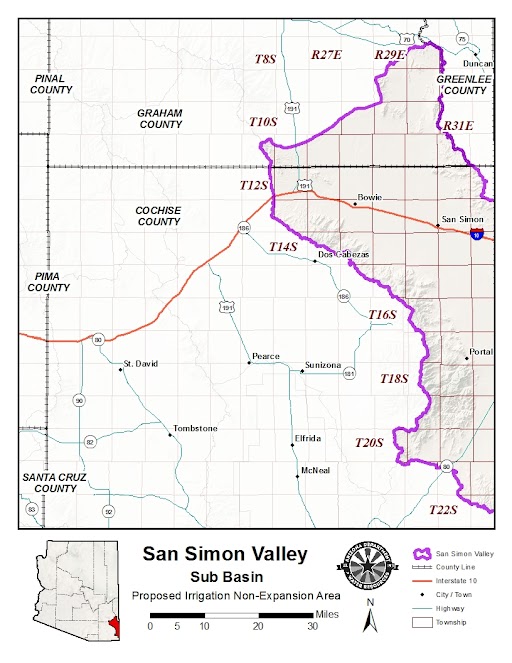
A map of the Sub-basin can be found at the bottom of this website. Table 1 below is a list of signatories to the petition.
| Table 1. San Simon INA Petitioners | |
| Petitioners: | |
| 1. A & P RANCH, LP | 11. S & H FARMS |
| 2. BOWIE PECANS INC | 12. SAN SIMON ESTATE LAND COMPANY, LLC |
| 3. CHAPMAN FARMS, LLC | 13. URS ORCHARDS, LLC |
| 4. ENIA FARMS, LLC | 14. WHITETAIL CREEK ORCHARD, LLC |
| 5. FARMERS INVESTMENT COMPANY | 15. WPD PISTACHIO, LLC |
| 6. FOUR STAR PISTACHIO, LLC | 16. MICHAEL AND KAMI ALLRED |
| 7. H & R FARMS, LLC | 17. BRIAN AND GERILENE DRISCOLL |
| 8. HFT PECAN ORCHARD, LLC | 18. JEANETTE PIERCE |
| 9. J & P PISTACHIO RANCH, LLC | 19. TODD AND LESTI WEBSTER |
| 10. PISTA LAND COMPANY, LLC | |
A copy of the original petition can be accessed online at San Simon Petition 2025.
II. Analysis of Irrigation Users of Groundwater
A.R.S. § 45-433 (A)(1) requires the Department to verify that the petitioners represent irrigation users of groundwater.
Furthermore, because fewer than twenty-five entities signed the petition, the Department determined that an analysis of the total number of irrigation users of groundwater in the San Simon Valley Sub-basin was also required, to determine whether the petitioners represented at least one-fourth of the irrigation users of groundwater
in the Sub-basin.
For the purposes of this analysis, ADWR sought to identify individuals/entities who had irrigated within the Sub-basin within the five-year period preceding the date of the receipt of the Petition (September 15, 2025). Irrigate
is defined by A.R.S. § 45-402(18) to mean to apply water to two or more acres of land to produce plants or parts of plants for sale or human consumption, or for use as feed for livestock, range livestock, or poultry, as such terms are defined in section 3-1201.
To identify irrigation users of groundwater in the San Simon Valley Sub-basin, the Department utilized U.S. Department of Agriculture (USDA
) National Agriculture Imagery Program (NAIP
) aerial imagery, Cochise County Assessor information (both ownership data and parcel boundaries), Arizona State Land Department (ASLD
) agricultural lease information, aerial imagery available on Google Earth Pro™, and the ESRI World Imagery basemap.
Primary identification of irrigation was done using Arizona USDA NAIP imagery for the years 2021 and 2023. NAIP imagery is acquired by the USDA for each state every two years as leaf on
-imagery collected during the peak growing season at a 30cm or 60cm spatial resolution. Access to NAIP 2021 & 2023 imagery is provided by the AZGeo data repository through ArcGIS Online image feature services. After the initial identification of irrigation, ADWR also reviewed the ESRI World Imagery basemap, ESRI Landsat Explorer, and Google Earth Pro™ historic imagery to identify additional fields during the relevant timeframe.
Each available imagery source for the San Simon Valley Sub-basin was reviewed in detail using ESRI ArcGIS Pro software and the outlines of any visible irrigated fields were digitized. The size of each polygon was calculated in ArcGIS Pro in acres.
Parcel shape data was obtained from the most recent GIS data supplied by the County Accessors for Cochise and Graham counties (July 11, 2025 and December 30, 2024). ADWR did not identify any irrigated Graham County parcels within the sub-basin during the eligible time period. Current ownership of the irrigated Cochise County parcels was confirmed using the County Accessor’s parcel GIS Webmaps and the parcel information inquiry pages for the County Treasurer’s office.
The layer of irrigation acreage was matched to the parcel shape layer and assigned the appropriate ownership information. All parcels matched to an irrigated field were then compared to the list of petitioners and were identified as owned by petitioner or not.
The data table of irrigation users of groundwater
was then sorted by landowner, as identified by Cochise County Assessor records, so that a list of all landowners who had irrigated at least one parcel of two or more acres during the five years preceding the receipt of the Petition could be compiled.
Additionally, in order to fully evaluate the eligibility of all petitioners, if visible water application was found on parcels smaller than two acres, the ownership was compared to the list of unique irrigators to find the total irrigated acreage for each entity. However, this step did not add any entities to the list of irrigators and parcels whose owners irrigated less than two acres on all their property were then removed from the irrigated parcel list.
Several irrigated parcels were identified as ASLD property, and the ASLD parcel viewer map on their website was used to locate identify the holders of agricultural leases within the Sub-basin. There were not any irrigators added to the list after this identification.
The Department has so far determined that, as of September 15, 2025, when the petition was received, there were 49 irrigation users of groundwater in the San Simon Valley Sub-basin who did not sign the petition. The complete list of irrigation users of groundwater within the San Simon Valley Sub-basin who did not sign the Petition, as identified by the Department’s analysis to date, are listed in Table 2 below.
| Table 2. Non-Petitioning Irrigation Users of Groundwater within the San Simon Valley Sub-basin1 | |
| Non-Petitioning Irrigation Users of Groundwater: | |
| 1. 45 DEGREES NORTH LLC | 26. MAHAN L S & E KAY |
| 2. BAR D LAND & LIVESTOCK LLC | 27. MAHIL BROTHER FARMS INC |
| 3. BARAK NISIM & ALIN FAMILY TRUST | 28. MASSEY ENTERPRISES LLC |
| 4. BARNARD JASON N & CANDICE R LIVING TRUST | 29. MCGUIRE LIV TRUST |
| 5. BOWIE FARMS 456 LLC | 30. MOGA AGRI INDUSTRIES HOLDINGS LLC |
| 6. BUHARI FAMILY LIMITED PARTNERSHIP | 31. MORIN RANCH LLC |
| 7. CARLOS CORNERS LLC | 32. MRK INVESTMENTS LLC |
| 8. COPPER HORSE VINEYARD LLC | 33. NP ARIZONA REAL ESTATE 1 LLC |
| 9. CORE AGRICULTURE LLC | 34. OWENS HARRY V JR |
| 10. DAVIDS AGRIGOLD FARMS LLC | 35. PARKER RANCH LLC |
| 11. EAST FLANK VINEYARDS LLC | 36. PATT SUSAN D & STEPHEN P |
| 12. EDSON DONALD & MELISSA | 37. PIATIGORSKY IGOR SALES INC |
| 13. EVON DELPHI LLC | 38. PREMIUM PECANS INTERNATIONAL LLC |
| 14. EVANGEL PARTNERS LLC | 39. RUDRA LLC |
| 15. EXCEPTIONAL PISTACHIO LLC | 40. RIVERS LARRY D TRUST OF |
| 16. FIDELITY NATL TITLE AGY INC | 41. SBS PACIFIC PROPERTIES LLC |
| 17. FORT BOWIE RANCHES LLC | 42. SHAW TIA MONIQUE TRIER |
| 18. HERNADEZ OSCAR ALBERTO & VILLA CHRISTINA | 43. SILVERADO FARMS LLC |
| 19. HNDEZ FARM LLC | 44. SKYLINE ORCHARDS LLC |
| 20. JOHNSON ALLEN PHILLIP | 45. STAR 50 PISTACHIO LLC |
| 21. KANG FARMS LLC | 46. WEIS SAMUEL K |
| 22. KEIL DANIEL L & LENA M | 47. ZERKLE JACOB |
| 23. KHAN FESTUS J | 48. ZERKLE THOMAS A & JOSHLIN J |
| 24. KHAN RUBIN & MICHELLE M | 49. ZWICKEY TRUST |
| 25. LOW RISK INVESTMENTS LLC | |
1 This table lists the landowners of irrigated parcels to represent the irrigation user of groundwaterassociated with each respective parcel. |
|
III. Petition Review
The Department is in the process of determining whether the petition is valid pursuant to A.R.S. § 45-433 (A)(1). If you believe that you have irrigated lands within the Sub-basin between September 15, 2020, and September 15, 2025 and have not been included in the Department’s list of non-petitioning irrigation users of groundwater please contact the Department by sending an email to Olga Hart, AMA Establishments Director, at [email protected].