

Help Center
I want to…/How Do I…
Any of these actions can be done through our Constituent Portal. It will walk you through, step-by-step, for the filings you wish to submit or update.
ADWR maintains and updates the SOC registry database, including the names and addresses of the parties to the adjudications, the location and nature of claims, and payment of filing fees that are forwarded to either the Maricopa County Court (Gila Adjudication) or the Apache County Court (LCR Adjudication). The database is updated as new SOCs are filed, and as existing SOCs are amended or assigned due to changes in property ownership or other changes.
You can access copies (pdf) of SOCs filed in the adjudications. In order to search and view the imaged records you will need the SOC file numbers. For assistance you may call ADWR at 1-866-246-1414.
Helpful Tools
Decreed &
Proposed Water Rights Abstract Library

Special Master’s Water Case Index
Adjudications Bulletin
Decreed & Potential Water Rights Abstract Library
ADWR developed this database to help the public locate decreed and proposed water rights abstracts. Please note that Gila River and Little Colorado River General Stream Adjudications are ongoing, therefore the Adjudication Court has not yet addressed many claims for water use. ADWR will timely update this database as the Adjudications Court issues new proposed water right abstracts.
Monthly Docket
Early in the adjudication process, the court established a procedure whereby the Clerk of the Superior Court was to prepare a monthly docket containing specific information to be provided to parties. The procedure was outlined in Pre-Trial Order No. 1 (May 30, 1986). The clerk’s website allows customers to view the dockets prepared by the Clerk’s office. Dockets available online began in the year 2001 and are located at Clerk of the Court for Maricopa County's website. For access to dockets before 2001, please contact the Clerk of the Superior Court in Maricopa County.
Special Master’s Water Case Index
The Special Master maintains a website dedicated to the Water Case, including links to minute entries and orders, some dating back to 1986. The website provides a calendar of events, an overview of the case, an online newsletter, and rules of procedure.
The Arizona General Stream Adjudication Bulletin
The Office of the Special Master publishes the Arizona General Stream Adjudication Bulletin three times a year to provide information about proceedings in the Gila River Adjudication and the Little Colorado River Adjudication. The current issue and past issues are available to read.
Statement of Claimant Locator
Proposed and Approved Subflow Delineations by Watershed
Decreed and Potential Water Rights Abstracts
Phoenix Area Municipal
Providers’ Dashboard
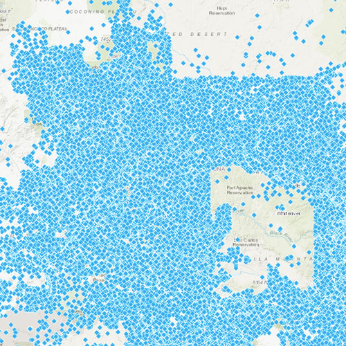
Statement of Claimant Locator
SOC's are documents filed in the Adjudication claiming a water right. This web application was developed to assist the public in locating filed SOCs. Please note that SOCs are plotted using the legal location information provided in the filing, and may not show up in the exact location described. Additionally, not all filed SOCs were plotted due to incorrect or absent location information. The information contained in the SOC's has not been verified by the Department, and merely reflects the information provided by claimants in the Adjudication. This application does not include changes that are made to a claim as a result of the Department's investigation or a determination by the Court.
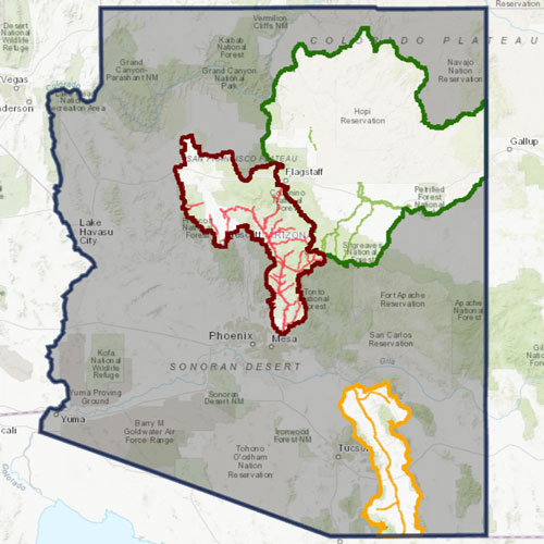
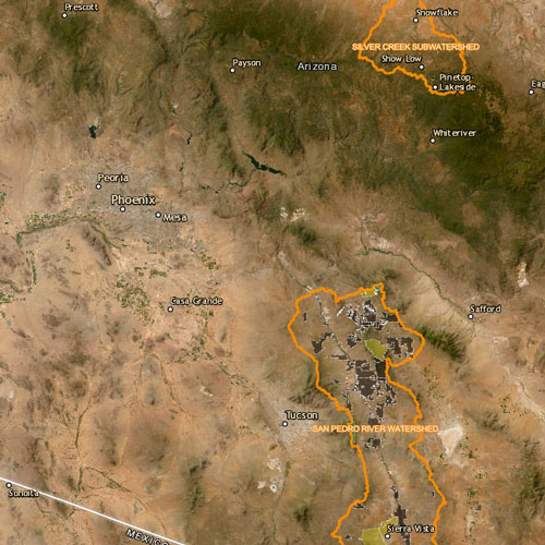
Proposed and Approved Subflow Delineations by Watershed
This interactive map show's ADWR's proposed subflow zones and subflow zones approved by the Adjudication Court associated with the following publications:
1. Supplement to 2014 Subflow Zone Delination Report for the San Pedro River Watershed
2. 2021 Subflow Zone Delineation Report for the Verde River Mainstem and Sycamore Canyon Subwatershed
3. 2023 Subflow Zone Delineation for the Remainder of the Verde River Watershed
Decreed and Potential Water Rights Abstracts
This interactive map was developed to aid the public in locating decreed and proposed water right abstracts.
Please be aware that proposed water right abstracts without maps are shown only as a property outline in this application. If you are unable to locate a proposed water right abstract here, please search the Decreed and Proposed Water Rights Abstract Library directly. Please note that Gila River and Little Colorado River General Stream Adjudications are ongoing, therefore the Adjudication Court has not yet addressed many claims for water use. ADWR will timely update this application as the Adjudications Court issues new proposed water right abstracts.
Decreed water rights depicted on this application may not reflect all historical decrees, including those issued as a result of Indian water rights settlements. Additionally, while land may be shaded as part of a decreed water rights area, this does not necessarily signify that the decree covers all water uses or water users within that area.
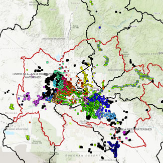
Phoenix Area Municipal Providers’ Dashboard
This interactive map provides data related to the Statement of Claimant filings, surface water filings, and well registrations made by Phoenix metro area Community Water Systems (CWS).
If a water provider meets the following criteria, the provider's filings and registrations are reflected on this dashboard:
1. The provider is within the boundaries of the proposed Salt River Valley HSR.
2. The provider is registered as a CWS.
3. The provider has filed a Statement of Claimant for municipal use.
The Salt River Project's filings and registrations were also included as an exception to the above criteria, as they are a major supplier to the various municipal claimants.
Frequently Asked Questions
How Did These Adjudications Start?
The Gila River and Little Colorado River adjudications trace their origins to proceedings initiated in the 1970s under the then-existing general adjudication procedures set forth in Arizona Revised Statutes sections 45-231 to 45-245. On April 26, 1974, the Salt River Valley Water Users' Association (SRP) filed a petition with the Arizona State Land Department (SLD) to determine the water rights in the Salt River above Granite Reef Dam (but excluding the Verde River). On February 24, 1976, SRP filed a similar petition for the Verde River and its tributaries. On February 17, 1978 and on April 19, 1978, utilizing these same statutes, the Phelps Dodge Corporation filed petitions with SLD to determine the water rights of the Gila River system and source and the Little Colorado River system and source. These petitions sought adjudication of the Upper Gila River watershed and of portions of the Lower Gila River watershed. On April 3, 1978, ASARCO, Inc. filed a petition with SLD for the adjudication of the San Pedro River and its tributaries.
On December 24, 1980, the Buckeye Irrigation Company filed a motion to intervene and a petition to enlarge the scope of the adjudication with respect to areas of the Gila River watershed not included in the previously filed petitions. This motion and petition were granted on March 17, 1981, and included the Agua Fria River watershed and portions of the Lower Gila River watershed. At the time, there was litigation pending in federal court which sought an adjudication of the Santa Cruz River watershed in Pima and Santa Cruz counties. Because of this litigation, the Maricopa County Superior Court, by granting the Buckeye Irrigation Company petition for adjudication of additional rights, did not include that portion of the Santa Cruz River watershed located in Pima and Santa Cruz counties. Following the conclusion of that litigation, on October 30, 1985, the Buckeye Irrigation Company filed a petition, granted by the Superior Court, for the inclusion of those portions of the Santa Cruz River watershed.
In April 1979, the Legislature amended the general adjudication procedures. Under these amendments, the Salt River, Verde River, and Gila River adjudications were transferred from SLD to the Maricopa County Superior Court. The San Pedro River adjudication was transferred to the Cochise County Superior Court. In November 1981, the Arizona Supreme Court consolidated these adjudications into one proceeding assigned to the Maricopa County Superior Court under the caption In re the General Adjudication of All Rights to Use Water in the Gila River System and Source, Nos. W-1, W-2, W-3 & W-4 (Consolidated).
Under the amended statutes, the Little Colorado River Adjudication was transferred to the Apache County Superior Court where it is litigated under the caption In re the General Adjudication of All Rights to Use Water in the Little Colorado River System and Source, No. 6417.
These cases were assigned to the Maricopa and Apache County Superior Courts because these are the counties where the largest number of potential claimants reside. Pursuant to the amended statutes, summons were issued in both adjudications and served on potential claimants in each watershed. Copies of the summons were served upon all persons listed in property tax assessments in each watershed and on all persons in the watershed who had, at the time, any kind of water rights filing on record with the Arizona Department of Water Resources (ADWR). In July 1984, a special notification was made to owners of registered wells in the Upper Salt River and San Pedro River watersheds. The summons required the filing of a statement of claimant with ADWR if the person claimed a water use from a well in the watershed.
Each watershed in the Gila River system was noticed. The original filing deadlines were:
Gila River Adjudication:
Upper Salt - June 30, 1980
January 4, 1985 (groundwater claims)
San Pedro - July 11, 1980
January 4, 1985 (groundwater claims)
Agua Fria - November 1, 1985
Upper Gila - November 1, 1985
Verde - November 29, 1985
Lower Gila - January 20, 1987
Upper Santa Cruz - August 3, 1987
Little Colorado River Adjudication:
December 23, 1985
Original deadline was May 1, 1982. Next deadline was set for June 30, 1985 after Supreme Court held that the McCarren amendment removed any federal impediment to Arizona state courts jurisdiction over Indian water rights.
Who Will Be Affected By The General Stream Adjudications?
Any person or entity who uses water or has made a claim to use water on property within the Gila River system or within the Little Colorado River system, potentially may be affected. The legislature has charged the Arizona Superior Court with quantifying and prioritizing validly existing water rights claimed in these watersheds. The final court decrees will establish the existence and ownership of claimed water rights, as well as important characteristics of the water rights including location of water uses, quantity of water used, and date of priority of the water rights.
What Is The Position Of Special Master?
The Special Master is a judicial officer appointed by the Arizona Superior Court to hear cases arising out of the adjudications and report on legal and factual issues designated by the Superior Court. After resolving all the objections to the hydrographic survey reports, the Special Master will present a report and recommended final decree to the Superior Court judge assigned to each adjudication. After hearing and resolving any objections to the Special Master's report, the judges will issue the final decree for each watershed. Special Master’s website.
Should A Claim Be Filed For Some Potential Future Use?
No. Under the Arizona system of water law, water rights cannot be established or reserved for some potential future use. Water rights can only be established through proper legal appropriation and putting the water to actual beneficial use.
WHAT IS A NEW USE SUMMONS?
A new use summons is an order from either the Maricopa County Superior Court (Gila River Adjudication) or the Apache County Superior Court (Little Colorado River Adjudication) that directs you to assert any claims to water rights that you may have by filing the appropriate court approved forms. These forms are known as statements of claimants (SOCs).
WHY DID I RECEIVE A NEW USE SUMMONS?
Because the property you own is located within lands drained by either the Gila River or Little Colorado Rivers and their tributaries. Therefore, the use of water on your property may be affected by on going court proceedings known as the Gila River Adjudication and the Little Colorado River Adjudication. The adjudications are comprehensive court proceedings to determine the nature, extent, and relative priority of rights to use water in the Gila River System and Source and the Little Colorado River System and Source. The Arizona Department of Water Resources (ADWR) serves new use summons periodically to potential claimants within the adjudication boundaries. You are being served with a new use summons because the records of ADWR indicate that you may have initiated a new use of water since the last summons was issued.
WHAT DO I NEED TO FILE?
For each type of water use, you must file a statement of claimant (SOC) that describes your claimed water use. For each of the watersheds in the two adjudications, there are four court-approved SOC forms. The form you need to file depends on your type of water use. There is an SOC form for each of the following uses: (1) domestic, (2) irrigation, (3) stockpond, and (4) other uses. You may need to file more than one SOC if you have multiple water uses.
You may download SOC forms from ADWR’s website. Statement of Claimant and New Use Summons Forms or contact ADWR for assistance
DO I NEED TO FILE AN SOC EVEN THOUGH I ALREADY HAVE A PERMIT, CERTIFICATE, OR OTHER APPROVAL FROM ADWR?
Yes, you must file an SOC so that the adjudication court will be aware that you are claiming a right to use water. Even though you may have already received a permit, certificate, or other form of approval from ADWR for your water uses, an SOC must be filed for the adjudication process. The adjudication court will ultimately determine the nature, extent, and relative priority of all water rights for which an SOC has been filed.
HOW DO I LOCATE MY WATERSHED?
You may locate your watershed by viewing or downloading the map on ADWR’s website Map of Adjudicated Areas in Arizona. You may also contact ADWR for assistance. See “HOW DO I CONTACT ADWR FOR FORMS AND TO GET ANSWERS TO QUESTIONS?” at the end of this document.
DO I OBTAIN A WATER RIGHT BY FILING AN SOC?
No, you do not obtain a right to use water by filing a SOC. Rights to use water must be acquired in accordance with state law. According to state law, to initiate a new use of water, or to increase the amount of water used under a current water right, you must obtain the appropriate permit, certificate, or other approval from ADWR. For more information on this process, please call ADWR at (602)-771-8500.
SHOULD I FILE AN SOC IF I USE WATER FROM A WELL?
For each watershed, ADWR provides a report to the adjudication court that identifies all uses of water within the watershed, including uses from wells. The adjudication proceedings may include water uses from wells.
Under state law, appropriable water includes surface water and certain subsurface water referred to as subflow. Subflow is underground water that is hydraulically connected to a stream and is considered to be part of the surface stream itself.
If your well is pumping subflow or causing an impact to the subflow zone of a stream, then water uses from your well will be subject to the jurisdiction of the adjudication court. All persons using water from a well should file a Statement of Claimant - or confirm that a Statement of Claimant has been filed on their behalf- claiming the right to use water from their well(s). Failure to file a water right claim could result in forfeiture of the water right. (See Arizona Revised Statutes § 45-254(F)).
WHAT IF I SOLD THE PROPERTY WHERE I USED MY WATER RIGHT?
If you have sold the property where you use your water right, you should contact ADWR so that the new owners may be contacted. If you sold your property and you have already filed an SOC, you should complete the form entitled “ASSIGNMENT” of statement of claimant.
The assignment form may be downloaded from ADWR’s website Statement of Claimant and New Use Summons Forms or you may obtain a form by contacting ADWR.
See “HOW DO I CONTACT ADWR FOR FORMS OR TO GET ANSWERS TO QUESTIONS?” below.
WHEN DO I HAVE TO FILE AN SOC?
Generally, you should file your SOC within 90 days of receipt of the new use summons. However, state law allows you to file an SOC even after the initial 90-day period. Upon filing your SOC, you will be entitled to receive notification of adjudication activities that may affect your water rights.
The statement of claimant should always be current. An SOC may be amended, without leave of the Superior Court, before the conclusion of hearings, by the Special Master, for a subwatershed or federal reservation. After the Special Master has completed hearings on a subwatershed or federal reservation or on the SOC and has filed a report with the Superior Court for the entire subwatershed or federal reservation, a claimant must file a motion with the Superior Court for permission to file an amended statement of claimant. The court will exercise its discretion to grant or deny the motion.
ARE THERE ANY OTHER REQUIREMENTS FOR AN SOC?
After you file an SOC, you must notify ADWR of any of the following: (1) a change in your address; (2) an assignment of your SOC to another person; (3) a transfer to another person of all or part of the land for which a water right has been claimed; and (4) a transfer to another person of all or part of the water right claimed when the water right is severed and transferred to another parcel of land. You must notify ADWR within 30 days of any of these changes using the forms available at ADWR, or by downloading them from ADWR’s website, Statement of Claimant and New Use Summons Forms
See “HOW DO I CONTACT ADWR FOR FORMS OR TO GET ANSWERS TO QUESTIONS?” below.
HOW MUCH DOES IT COST TO FILE AN SOC?
The filing fee for an individual is $20.00 for each SOC filed, unless there is more than one use served from a common source of supply. If more than one use is served from a common source of supply and more than one SOC must be filed, then only one filing fee of $20.00 must be paid. The filing fee for a corporation, municipal corporation, the State or any political subdivision, or an association or partnership is two cents for every acre foot of water claimed per year, or $20.00, whichever is greater.
HOW DO I PAY?
The filing fees may be paid in cash (in person only), by credit card, or by check or money order made payable to the “Arizona Department of Water Resources.” Unless the filing fees have been paid in full, your water right will not be included in the adjudication process.
WHAT HAPPENS IF I DO NOT FILE?
If you do not file an SOC, you may lose your water right, and you may be prevented from asserting that water right later. This could happen even though you have received a permit, certificate, or other approval from ADWR.
HOW DO I CONTACT ADWR FOR FORMS OR TO GET ANSWERS TO QUESTIONS?
Forms may be downloaded here. Forms are also available upon request to ADWR at the following address and telephone number:
Arizona Department of Water Resources
1110 W. Washington Street, Suite 310
Phoenix, Arizona 85007
Telephone: 1-866-246-1414
Fax: 602-771-8686
You may also call this number for answers to questions about the new use summons and the adjudication process. Please note that ADWR receives a high volume of telephone calls regarding the adjudications, and staff responds to calls in the order they are received. If you leave a message, your call wills be returned as soon as possible. However, reductions in statewide services stemming from budget cuts may result in delays. Thank you for your patience.